Konect Explorer
Explore assets, inspections and external GIS data together in a live map environment.
How Konect Explorer works
The Konect Explorer demo tool provides deep insight into Konect’s capabilities.
Explore the interactive map view in a demo environment, along with links to product information and resources. Learn about Konect functionality, integrations and API, and how Konect can improve business outcomes.
The demo environment has been created as a collaborative platform to help build and optimise a Konect environment, so you can even export data and take screenshots of the app to assist with dataset form design.
- Designed to work on a web browser, or via a Konect API key, you can visualise the inspection and asset data on a live map, overlay open government and ESRI datasets alongside it, and draw or import your own spatial data for context.
- No login required, but you will need to complete a short form to gain access to the specific demo environment you want to explore.
- Works on PC and mobile devices, with a different layout on each device. On desktop the data panel sits on the left and the resources panel on the right, both alongside the map. In the mobile version, these panels collapse into toggled overlays so the map itself has the full screen — tap the panel icons to open and close them.
- Every new browser session opens with a welcome screen offering a guided product tour. Once you have completed the tour, you can skip it in future sessions.
Konect Explorer functionality
Data Panel
Manage your spatial data from one place. Browse Konect datasets, connect to ESRI services, and control your map layers without switching tools.
Layer List
See everything loaded on your map at a glance. Toggle visibility, zoom to a layer’s extent, or remove layers you no longer need.
Konect Demos
Explore what Konect can do right away, using real data. Predefined layers load automatically, so there’s nothing to set up first.
Konect API Panel
Bring your own organisation’s data into the tool. Enter your Konect API key to load your live environment and view it alongside other spatial data. Don’t have a key yet? Request a trial API key from within the app.
Search
Find any address or point of interest across Australia in seconds. Search places, landmarks and street addresses, powered by the HERE maps service.
ESRI Feature Services Panel
See what’s possible when you combine datasets. Add open data from major councils around Australia and view it alongside your existing Konect data.
New to Konect? Use this panel to explore GIS data for local government areas across Australia first. When you’re ready, GIS plugins let you import these datasets into Konect from ESRI ArcGIS, QGIS or MapInfo.
Drawing Tools
Build a custom area of interest without leaving the map. Import GeoJSON files to view alongside Konect and ESRI data, or sketch a new area from scratch using the drawing tools. Anything you draw in Konect Explorer can be imported into Konect via Konect Manager or the GIS plugins.
Basemap
Switch between map styles to suit the task at hand. Choose from OpenStreetMap, satellite imagery, topographic, dark mode and more.
Chatbase AI Assistant
Get quick answers about Konect Explorer or the wider Konect application, without digging through documentation.
Try Konect Explorer now
Choose a use case below, complete a short form and then you’ll be redirected to the demo.Roads Management
This demo allows asset and infrastructure owners to visualise road ownership and responsibility boundaries alongside overlapping infrastructure like rail freight corridors, electricity transmission, seaports, airports and intermodal terminals. It can also be used for maintenance planning, compliance reporting and cross-agency coordination where road, rail and utility assets intersect.
Datasets for the roads demo include road networks (NSW road segments, national freight roads), transport infrastructure (stations, traffic lights, seaports, airports, intermodal terminals) and electricity transmission lines.
Facilities Management & Coverage
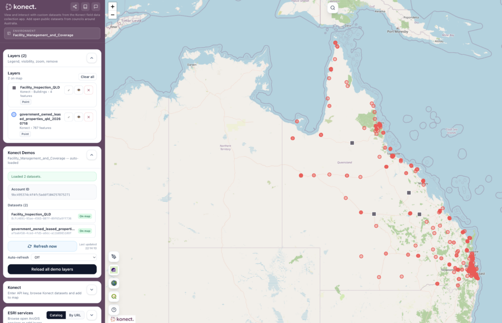
This environment covers Queensland government-owned and leased properties alongside a set of Konect facility inspection records.
The demo shows open data enrichment, with a large public asset register overlaid with Konect inspections to show how a state-wide facilities portfolio could be brought into a structured inspection workflow.
Street Trees & Vegetation Management
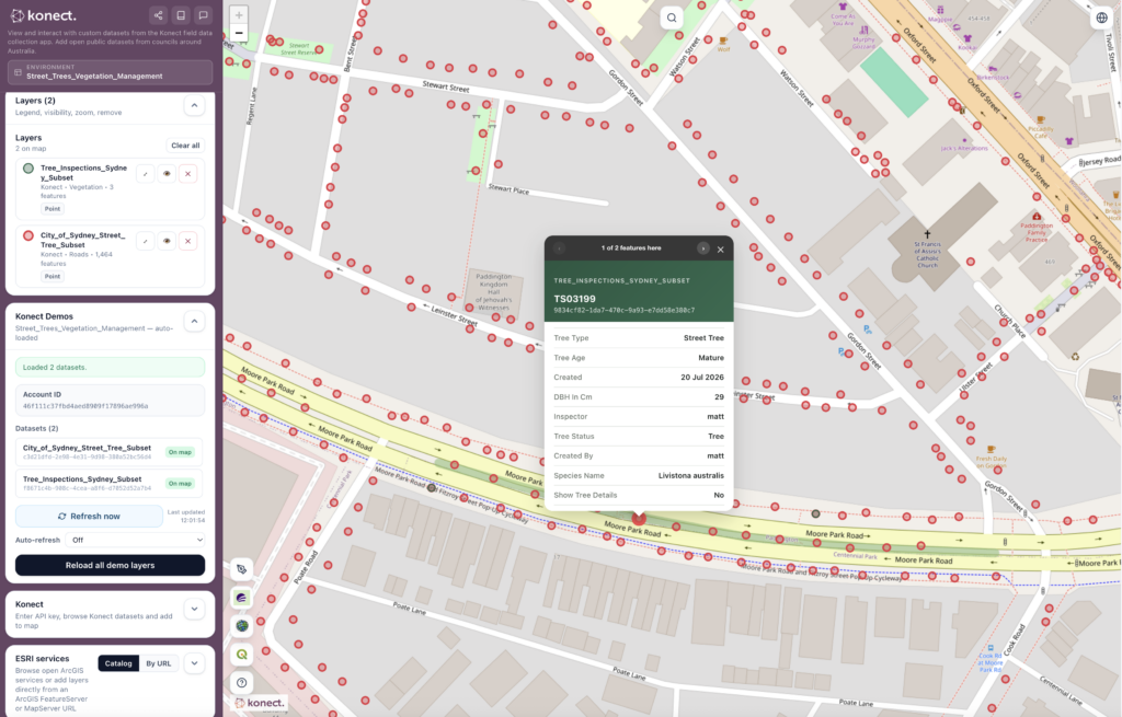
Centred on Sydney, this environment pairs a Sydney street tree register (including species, canopy, height and DBH) with a Konect field inspection dataset covering a subset of the same trees (condition, inspector and approval status).
This is excellent for councils or vegetation management contractors conducting tree audits or asset condition programs.
What our customers say
“Konect’s capture of real time data across the 1200km of road networks provides interactive reports to assist with grant funding opportunities. The patterns it discovered really helped us improve productivity.”
Natasha Jackson
East Arnhem Regional Council
Shane Tepper
Northern Territory Government
Paul Nicholson
City of Greater Bendigo
Guide to using Konect Explorer
Each demo environment loads two layers by default: one representing an asset dataset (e.g. a council’s street tree register or a leased-property register) and one representing Konect-collected inspection records against those assets. Both are listed in the Layers panel, where each can be shown, hidden or zoomed to independently using the eye and zoom-to icons next to its name.
Clicking any point on the map opens a record card. Where an asset location has both an asset record and an inspection record stacked at the same point, the card header shows “1 of N features here” with arrows to step between them — this is how a user toggles between the underlying asset record (e.g. tree species, canopy size, install date) and the inspection record collected against it in the field (e.g. inspector name, condition status, approval state). The colour of the record header and the layer’s marker colour in the legend both indicate which dataset a given record belongs to.
The Konect panel in the Data Panel accepts any Konect API key, not just the demo account’s. This is one of Explorer’s most useful reseller capabilities: if a client or prospect already has a live Konect environment, you can enter their key and browse their real datasets straight onto the map.
API keys are entered locally in the browser for the session and are not stored by Explorer beyond that session.
The ESRI Services panel lets you browse a catalog of open ArcGIS feature services (mostly Australian council and government data) or connect directly to any ArcGIS FeatureServer or MapServer URL, using the Catalog and By URL tabs respectively.
This is the core of Explorer’s consulting pitch: many resellers and Konect partners already win contracts to maintain physical assets — street furniture, trees, buildings, drainage — for councils and agencies that publish some or all of that asset data as open ESRI services. Explorer lets you pull that open data straight onto the map, alongside a live or demo Konect environment, to show a prospective client exactly what enriching their existing asset register with Konect inspections and field forms would look like — before any integration work has been scoped.
Data found this way can also be flagged as a candidate for publishing into Konect proper (to enrich or seed inspection forms), or linked to a client’s existing inspection forms as reference data.
Join Australia’s leading organisations using the Konect app