Smarter road management
Australia’s leading governments use the Konect app
Konect helps manage roads and infrastructure
Road-Wise Information
Ensures instant access to critical road management details, including maintenance schedules and road condition reports, directly through the app
Advanced Data Collection
Facilitates accurate data capture for road conditions and maintenance needs using forms with geo-tagging, ensuring precise location tracking and efficient maintenance planning.
Progress Reporting
Streamlines the reporting process with the ability to upload photos and documents in real-time, keeping all project stakeholders updated on road work progress and compliance.
Road Management Plans
Konect assists managers of road networks to demonstrate that they have implemented a best-practice approach to managing the risk of damage and injury for road users.
Konect provides a secure and efficient framework for recording defects and managing make-safe repairs. Time stamped electronic records allow managers to demonstrate their compliance with metrics stipulated in their Road Management Plan.
Global GBM assists numerous Organisations to regularly inspect the various classes of assets in the road corridor (signs, guide posts, lighting, road surface, footpaths etc.), log defects and prioritise make-safe repairs.
Accurate map location of defects allows repair crews to easily identify their worksite and positively confirm closure of hazardous defects. Road owners reap efficiency benefits and can significantly reduce insurance premiums by demonstrating a positive approach to risk management.
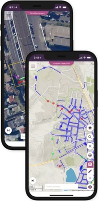
Road Furniture & Footpath Inspection and Maintenance
Global GBM’s map-enabled mobile solution improves the productivity of both inspectors and repair crews. Inspection and repair works are linked into a fully electronic workflow, making it easy to close out work requests and collect statistics on the work done.
Map linked data forms make it easy for inspectors to track which segments have been inspected and quickly mark the location of any defects. Intelligent data forms make sure defects are described consistently. Wireless data services upload all defects to the cloud database from where they can be easily reviewed and repairs prioritised.
Maps assist repair crews to quickly navigate to defect locations and positively identify the site and work requirements. No more paper forms, no more time wasted matching up work sites and work requirements.
Konect automatically collates audit records to protect against possible legal challenges around the state of the footpath network and steps being taken by the asset owners to minimise public risk.
Asset Capture
In Australia alone, the Roads and Infrastructure Market manages $100 billion in assets, including the roads themselves. However, this also includes many small items, such as road furniture, including lighting, signs, footpaths, barriers, and even the trees planted along the way. These need to be located, inspected, and repaired.
Global GBM provided unique map linked drawing tools that allow inspectors to accurately locate these assets at their GPS location or more commonly mark them on high resolution aerial imagery. In Australia spatial asset capture drives repair and maintenance regimes and provides critical observations that drive improved Asset Management software.
As-Build Surveys
Developers submit plans that detail the location of roads, footpaths and services to be established in new sub-divisions. As-built infrastructure invariably differs from those plans. Konect is an efficient tool for employees and contractors to validate final installations against the original plans for upload to your and your customers’ GIS system that will track these assets through their productive life.
Works Management
There are many areas in Roads and Infrastructure Management where personnel need to be dispatched to inspect or maintain assets in the field. Konect, with its unique combination of a manager’s desktop, wireless data service and mobile App is an ideal environment for assigning works to field crews and tracking tasks to completion. Integrations with Assets Management systems can be developed as required. Typically an Asset system will forward work orders to Konect and receive updates as works progress.
Limited time offer
Free 60‑Day Trial – Exclusive to the first 10 customers to claim!
Includes free consulting hours to customise Konect for your specific needs.
Built with you in mind
Road-Wise Info
Ensures instant access to critical road management details, including maintenance schedules and road condition reports, directly through the app.
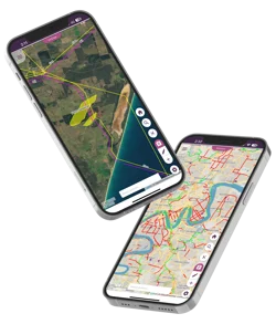
Real-time Geospacial Mapping
Track road conditions, worksites and maintenance activities with live mapping that gives councils, governments, and contractors full visibility over their networks.
Advanced Data Collection
Facilitates accurate data capture for road conditions and maintenance needs using forms with geo-tagging, ensuring precise location tracking and efficient maintenance planning.
Automated Workflows and Data Capture
Schedule inspections, dispatch tasks and record defects with GPS, annotated photos, and automated data entry—keeping records accurate, accessible, and free from paperwork errors.
Roadside Asset Management Anywhere
Manage signage, guideposts and lighting in line with Road Management Plans, as well as log inspections and emergency repairs via the mobile app—even without network coverage.
Progress Reporting
Streamlines the reporting process with the ability to upload photos and documents in real-time, keeping all project stakeholders updated on road work progress and compliance.
What our customers say
“Konect’s capture of real time data across the 1200km of road networks provides interactive reports to assist with grant funding opportunities. The patterns it discovered really helped us improve productivity.”
Natasha Jackson
East Arnhem Regional Council
Shane Tepper
Northern Territory Government
Paul Nicholson
City of Greater Bendigo
Get the latest news and exclusive webinar invitations
Subscribe now to receive news, product updates and invites to upcoming webinars.
Frequently Asked Questions
Our platform combines real-time geospatial mapping, automated workflows, and secure data capture to simplify inspections, defect logging, and repairs—ensuring work is scheduled, completed, and documented on time.
Yes. Every inspection, repair, and defect is time-stamped, mapped, and stored in a secure central database. This makes compliance with Road Management Plans trackable, verifiable, and easy to report, reducing legal risk.
Absolutely. The system manages roadside furniture such as signage, guideposts, and lighting, with the ability to log inspections and emergency repairs via our mobile app—even without network coverage.